Home
Hackney Downs Low Traffic Neighbourhood
Hackney Downs Low Traffic Neighbourhood
After considering traffic and air quality data, alongside responses provided by residents to this Commonplace page, the Council has made a decision to make the Hackney Downs LTN permanent. See hackney.gov.uk/hackney-downs-ltn for the full decision report, including the engagement report which includes the results from this Commonplace page.
We will continue to monitor the effects of the LTN and listen to feedback about the scheme. You can email comments to: streetscene.enquiries@hackney.gov.uk.
We are committed in our Transport Strategy to make Hackney’s roads safer for everyone living, working and visiting the borough. We aim to create an environment that will encourage more walking and cycling, improve air quality and reduce emissions in the borough. For further background to these measures, see the About the project page. To find out more about how we're maintaining access to properties, why we're acting so quickly and more, visit our Frequently Asked Questions page.
In the area north of Hackney Downs, we know that levels of non-local through-traffic are at times too high, including rat-running traffic trying to avoid congestion along Upper Clapton Road, Stoke Newington High Street and Northwold Road.
We also carried out a public consultation in January/February this year on proposals for a road safety scheme at the junction of Brooke Road with Evering Road. Analysis of the consultation responses revealed that several residents and key stakeholders were of the view that the proposed redesign of the junction at Brooke Road and Evering Road, would not on its own reduce the issues in the wider area associated with through traffic and rat-running. The initial plans were reviewed and we decided that introducing traffic filters would be more appropriate to address these issues.
We have therefore introduced a type of road closure, known as a traffic filter (planters or bollards on the road, which prevent motor vehicles from passing through), at the following locations (see attached drawings):
This will encourage walking and cycling, promote social distancing and reduce non-local through-traffic on these streets.
If you are a resident or business in the area and you have a motor vehicle, you will still be able to drive to your home or business, but this may be via a different route.
Cyclists, emergency vehicles and refuse vehicles will be able to pass through the traffic filters.
The attached drawing also shows proposals for new School Streets in the area. You can have your say on the School Streets here .
How were the measures introduced?We introduced these measures from 24 August 2020, using solid planters on either side of the roads to reduce the carriageway width, but allowing enough space for cyclists and emergency and refuse vehicles to go through. Signs and road markings make it clear that regular vehicles cannot pass through. The closures may be enforced by cameras in order to deter vehicles driving through the closures. Implementation was expected to take up to a week.
Like any scheme, we would expect that each scheme will take a couple of weeks to settle in before the full benefits to walking, cycling and traffic levels are clear.
Have your sayThe filters were being introduced using an experimental traffic order for a maximum period of 18 months, which means you can see how the filters work in practice before having your say.
The views of residents and businesses, including any suggested changes to how schemes operate, will be taken into account before any decision on whether or not to make the measures permanent. This process is in line with specific guidance from Transport for London, and the Department for Transport, whose guidance states that: 'authorities should monitor and evaluate any temporary measures they install, with a view to making them permanent, and embedding a long-term shift to active travel as we move from restart to recovery’.
The experimental traffic order was advertised in the London Gazette and the Hackney Gazette on 13 August 2020.
The initial engagement period on this scheme ran until 2 March 2021, however we are extending this until 19 December 2021 to allow as many people as possible to have their say.
To have your say, please complete the survey below or email streetscene.consultations@hackney.gov.uk. You can also write to us by sending your comments to ‘Freepost Streetscene’.
Map (detailed drawing in link below):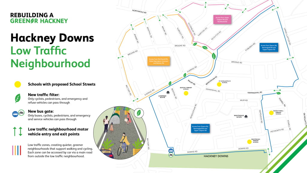 Traffic monitoring
We are monitoring traffic levels in and around the Hackney Downs low traffic neighbourhood, and have compared traffic levels in July 2021 to before the changes were implemented. View this PDF for full traffic monitoring.
Additional materials

This engagement phase has finished
...